MapTiler makes online map publishing easy. This open-source utility is actually a graphical user interface for GDAL2Tiles, part of the GDAL project. This image slicing tool will transform your files in TIFF, GeoTIFF, JPEG2000, or MrSID maps (among other formats) into high-quality tiles that not only fit perfectly each other but that also help Internet browsers to display and move around large maps in an easier and more efficient way.
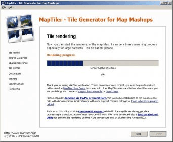
MapTiler can slice any Google Map, Yahoo Map, Microsoft VirtualEarth, and OpenStreetMap image into perfectly fitting tiles in just a few steps. In fact, MapTiler’s interface is nothing but a useful wizard – divided into eight easy steps; it will guide you through the whole slicing process with the help of useful tips and explanations. Once you have defined the type of tile you prefer (compatible with Google Maps, Google Earth, WGS84 Plate Caree, or plain rasterized image tiles), you can add a specific georeference that the program will use to select the desired area more accurately. You can also decide on the zoom and the resolution of the “tile pyramid” – MapTiler creates an overlay of various graphical layers in order to render the best-quality map possible, and arranges them in the shape of a virtual pyramid. Then you can present your maps to various viewers – Google Maps, OpenLayers, and Google Earth viewers.
The result of the rendering process is stored in a newly-created folder, which is all you need to upload your map to your server and publish it in the Web. The map created is of top-notch quality.

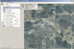
It is a tool designed to get small tile map images from Microsoft VirtualEarth.
A tool for integrating the maps of your choice into the Virtual Earth API.

It helps you get small tile hybrid images from Microsoft VirtualEarth.


Comments